


Trail Planner Map

daniel_2w
User
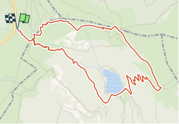

Length
6.5 km

Max alt
1345 m

Uphill gradient
436 m
Km-Effort
12.3 km

Min alt
923 m

Downhill gradient
436 m
Boucle
Yes
Creation date :
2023-03-30 08:41:23.756
Updated on :
2023-03-30 08:42:15.129
0m
Difficulty : Easy

FREE GPS app for hiking
 SityTrail
IGN / Geographical institutes
SityTrail Plus
The world is yours!
About
Trail Nordic walking of 6.5 km to be discovered at Grand Est, Vosges, La Bresse. This trail is proposed by daniel_2w.
Positioning
Country:
France
Region :
Grand Est
Department/Province :
Vosges
Municipality :
La Bresse
Location:
Unknown
Start:(Dec)
Start:(UTM)
351550 ; 5322242 (32U) N.
Comments